
PAUATAHANUI BURIAL GROUND TRUST DEED
The renovation of Pataka Museum’s storage area in 2017 brought to light two documents that are probably the oldest existing paper records of early Porirua.
In 1856 the village of Pahautanui (now called Pauatahanui) was the only settlement in the Porirua area. Thomas Hollis Stace, who had arrived with his family from Tasmania in 1853, bought a piece of land on the southern edge of the village. He saw that the village lacked a school, church and cemetery; so he donated an acre of his land to help fill these gaps.
The details of this generous gift were set down on two sheets of parchment on 6 December 1856, and it is this 161-year-old Trust Deed that has emerged from the Pataka storeroom.
This photo shows the front page. The map shows that the donated acre lies near the then-shoreline of the Pauatahanui Inlet, and above what is now part of SH 58 between the roundabout and Lighthouse Cinema corner.
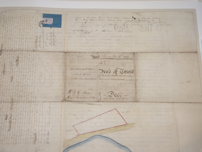
The Trust Deed called for the building of a chapel, to be used as a school and for Protestant worship, and for the rest of the land to become a public ‘Burying Ground’. It reserved part of the land to be the burial plot for Stace and his descendants.
Thomas Hollis Stace received “the sum of five shillings of lawful British money” for his generosity. The Trust Deed sets out the dimensions of the land, roughly 200 links by 500 (40 x 100 metres), and describes its location next to the public road that passed through Section 63. At the time, as there was no formal system of land surveying and registration in New Zealand, the Trust Deed served as the title to the land.
On 9 July 1887, as the result of the passage of the Cemeteries Act 1882, further text was added to the deed. It confirmed the existing Burial Ground Trustees in their role, but renamed them ‘Managers’, and gave them additional rights and obligations. It also updated and corrected the legal description of the land, following a survey, which showed the land to be five-sided rather than rectangular, and confirmed that its boundary included a small ‘spike’ in the western corner. The addition to the Trust Deed also reiterated the Stace family’s right to a certain plot, and described its location within the Burial Ground more accurately.
The chapel described in the Trust Deed was built in 1857, and was used as the first school in Pauatahanui for a short time. From the beginning it was used for church services, mainly by the Church of England. By 1887 it had fallen into disrepair, and was no longer used. In 1908 it was sold to sold to a local publican, Matthew Moynihan, who demolished it and used the timber to build a shed.
The documents have been copied in high resolution and in colour, and these copies are also held at Pataka. The cost of the copies was met by the PRA using profits from the sale of the Pauatahanui history book.